
After almost four weeks of dry weather, rain is finally returning to California. The wet pattern arriving this week will come in multiple waves, with the most meaningful rainfall expected toward the end of the week. Temperatures will stay cool, and while early storms bring limited impact, the final system could deliver widespread rain and fresh mountain snow.
Storm 1: Light Rain Limited to California’s North Coast
The first storm arrives Monday evening, but its effects will be confined to the far North Coast, including Humboldt and Del Norte counties.
This system is welcome news for places like Eureka, which has seen very little rain so far this month. A weak cold front connected to a low-pressure system near British Columbia will bring light to moderate rain from Monday afternoon through early Tuesday.
Areas expected to see rain include:
- Eureka
- Crescent City
- Siskiyou Mountains
This storm is the weakest of the week and will not reach the Bay Area. As the system weakens overnight Tuesday, most of California south of Mendocino County will remain dry.
Storm 2: Light Rain Breaks the Dry Streak
The second storm follows quickly, arriving by Tuesday afternoon and evening. This system is stronger and pulls in more moisture from the Pacific, allowing rain to move farther south.
Where and When Rain Is Expected
Late Tuesday night:
- Mendocino County
- Northern Sacramento Valley
- Sierra foothills
After midnight Wednesday:
- North Bay, especially along Highway 101

Early Wednesday morning:
- San Francisco
- Oakland
- Peninsula
This will likely create a damp Wednesday morning commute, but rainfall totals will be light.
Rainfall Totals
By the time this system exits Wednesday morning:
- North Bay: up to 0.25 inches
- South of the Golden Gate: around 0.10 inches or less
While this officially ends the dry streak, it will not significantly impact drought conditions.
Sierra Snow Outlook
Snow levels remain high near 8,000 feet, meaning most Sierra ski resorts will see rain instead of snow. Only the highest peaks may receive light snowfall.
Storm 3: The Most Important System of the Week
The third storm, expected late Friday into early Saturday, has the best chance to deliver meaningful rain across the Bay Area and fresh snow in the Sierra.
Why This Storm Matters
By the end of the week, the jet stream is expected to align more directly across the Pacific. This setup helps storms stay stronger as they move into California and allows them to tap into subtropical moisture, also known as an atmospheric river.
A developing low-pressure system offshore will further enhance rainfall potential.
Rain Timeline
- Late Thursday night: North Coast
- Friday morning: North Bay
- Friday afternoon and evening: San Francisco, East Bay, South Bay
Expected Rainfall Amounts
- North Bay valleys: 0.5 to 1.5 inches
- San Francisco & Oakland: around 0.5 inches
- Farther south: lighter totals
Exact totals may change, but this system has the highest rainfall potential of the week.
Best Snow Chances in Weeks
This storm also brings the best snow opportunity the Sierra has seen recently. Snow levels could drop to around 6,000 feet by Friday night.
While the storm will move through quickly, a few inches of snow could fall at lower elevations, offering a much-needed boost for ski resorts.
What Happens After the Storm?
Once the system exits early Saturday, conditions should dry out quickly. However, weather patterns suggest that additional rain and snow chances may continue into Christmas week, with more frequent but moderate storms expected.
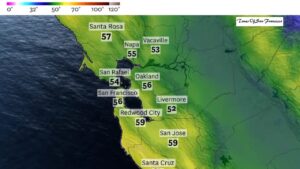
Bay Area Weather Breakdown for Monday
San Francisco
Mostly cloudy in the morning with partial sunshine later. Highs in the low to mid-50s. Clouds and fog return overnight with lows near 50.
North Bay
Mostly cloudy, especially near the coast. Highs range from upper 40s to mid-50s. Fog returns overnight.
East Bay
Morning clouds followed by partial sunshine. Highs in the upper 50s to near 60 in many areas. Cooler and cloudier farther north.
Peninsula
Low clouds and fog in the morning, gradual clearing later. Highs in the upper 50s. Overnight lows near 50.
South Bay
Cloudy morning with afternoon sun. Highs in the upper 50s to low 60s. Mild overnight temperatures.
Conclusion
California’s dry stretch is finally ending, with rain returning in stages this week. While the first two storms bring limited impact, the late-week system could deliver widespread rain and fresh Sierra snow. This shift toward a more active weather pattern may continue into the holiday season, offering hope for much-needed moisture across the state.