The Bay Area is finally getting a short break after a week filled with heavy rain, strong winds, and messy holiday weather. While conditions are calmer now, meteorologists say the rainy season is far from over, and more showers are expected later this week.
Stormy Holiday Week Finally Winds Down
Over the past week, several rounds of storms moved across California, bringing widespread rain and gusty winds. These systems caused travel issues and wet conditions during the holidays. The most intense weather has now moved out of the region, offering residents a brief period of calmer conditions.

The biggest change is in the atmosphere itself. After days of moisture-heavy air, the Bay Area is now experiencing much drier conditions compared to last week, when the air was packed with water vapor.
Why the Weather Is Calmer Right Now
This temporary break is linked to a shift in large-scale weather patterns. The powerful low-pressure system that fueled last week’s atmospheric river storms is finally moving east. At the same time, a high-pressure system is building over the eastern Pacific.
As this happens, a smaller piece of the storm system will spin into a separate low-pressure area off Southern California. Northern California and the Bay Area will mostly remain under high pressure, which helps keep skies clearer and weather calmer.
Offshore Winds and Cooler Nights
Offshore winds will develop as part of this pattern. While these winds often raise fire concerns, that won’t be an issue this time since the ground is fully soaked from recent rains. Instead, the winds will help dry out the air through Tuesday.
This setup creates classic Bay Area microclimates, including cold mornings in inland areas, possible tule fog in the Sacramento and Central valleys, and sunny but crisp afternoons across much of the region.
Rain Returns by Midweek
The calm weather won’t last long. By Wednesday, the offshore low-pressure system will drift north along the California coast. As it moves closer, cloud cover will increase and scattered showers are expected across the Bay Area.

Rain totals are not expected to be very high, but brief heavier downpours could occur Wednesday evening. These could lead to minor street flooding in urban areas. There is also a small chance of a thunderstorm due to colder air higher in the atmosphere.
More Storms Expected Into the New Year
Looking ahead, forecasters say the active winter pattern will continue. Another storm system is expected to arrive on Friday, bringing additional rain. The takeaway is clear: while the Bay Area gets a short pause, winter weather is not done yet.
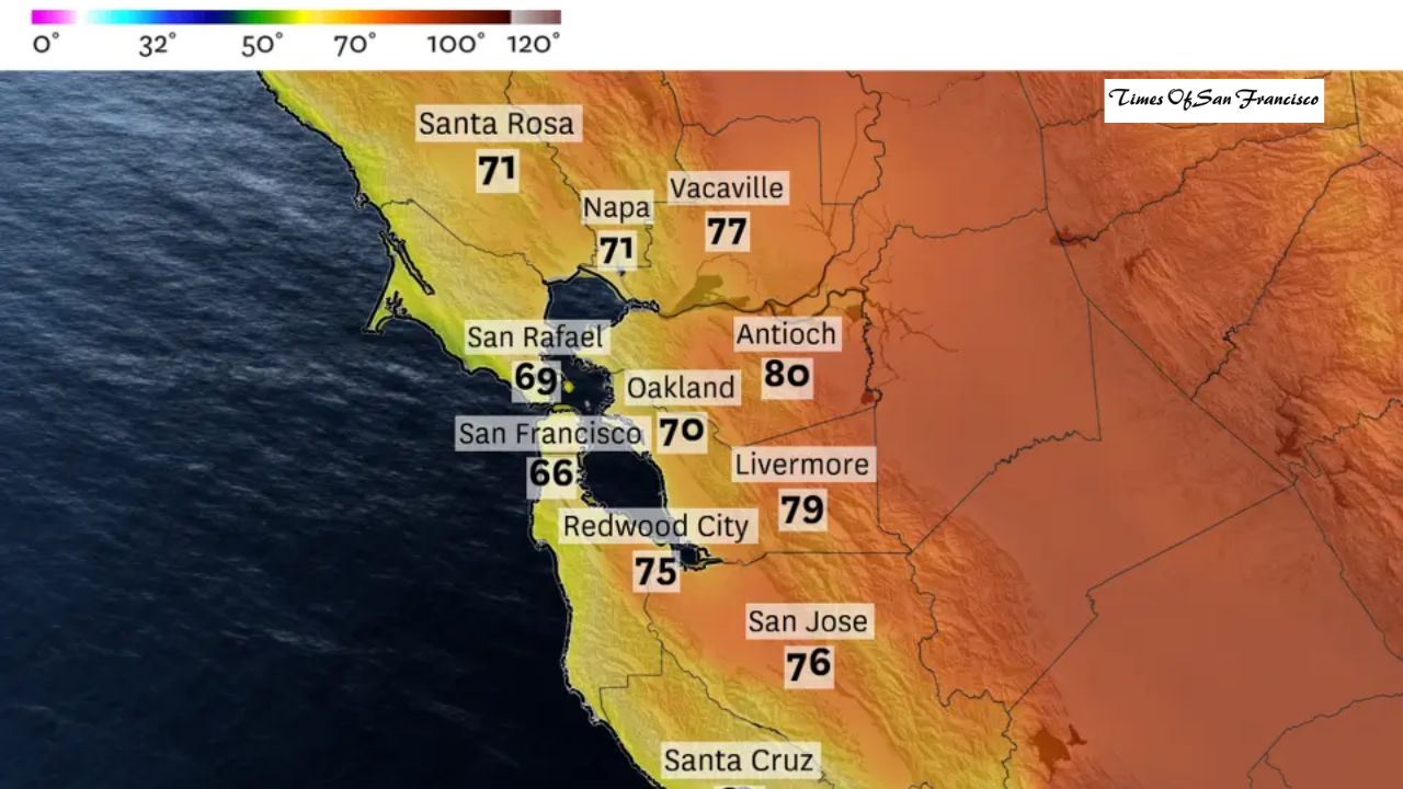
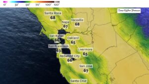
Monday Weather Forecast by Region
San Francisco
Monday will be sunny and cool, with afternoon temperatures reaching the upper 50s. A light northeast breeze develops during the day, especially near the water. Overnight temperatures drop into the lower 40s under mostly clear skies.
North Bay
The morning starts cold, with patchy frost possible in sheltered valleys. Sunshine returns quickly, and highs reach the upper 50s. Monday night stays clear and chilly, with lows between the mid-30s and lower 40s.
East Bay
Clouds early Monday give way to sunshine by midday. Afternoon highs remain cool, reaching the lower 50s. A light northeast breeze continues through the day. Overnight temperatures fall into the mid-30s, with frost possible in inland valleys.
Peninsula
Expect sunny and cool conditions Monday, with highs in the upper 50s. A light to moderate northeast breeze develops, especially near the bay and higher elevations. Nighttime lows drop to around 40 degrees.
South Bay
Monday will be mostly sunny, with afternoon highs near 60 degrees. Winds remain light from the north. Overnight conditions turn cooler, with lows dipping into the upper 30s.
Conclusion
The Bay Area is enjoying a brief pause after a stormy holiday stretch, with dry air, sunshine, and cool temperatures through Tuesday. However, rain is expected to return by midweek, followed by another storm system later in the week. Residents should enjoy the calm weather while it lasts, as winter conditions remain firmly in place.