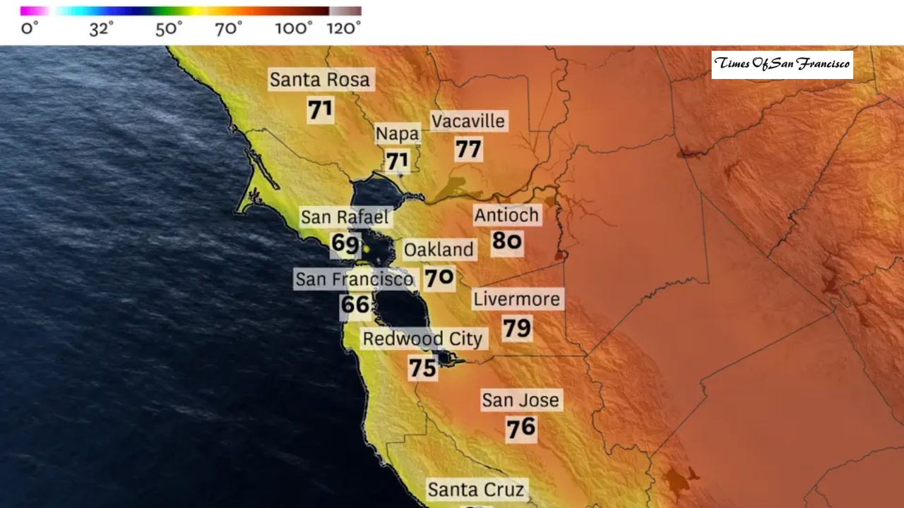
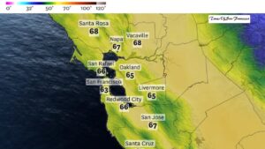
A strong storm forming off the California coast could rapidly intensify into a rare and dangerous weather system known as a bomb cyclone as it approaches the Bay Area next week. Forecasters warn the storm may bring intense rain, widespread flooding, and damaging winds just days before Christmas.
What Is a Bomb Cyclone?
Although the term “bomb cyclone” is often used as a buzzword, it has a specific scientific meaning. A storm officially becomes a bomb cyclone when its air pressure drops very quickly in a short period of time.

At the latitude of San Francisco, this process — called bombogenesis — occurs when a storm’s central air pressure drops by at least 17 millibars within 24 hours.
Why This Storm Is Raising Red Flags
Weather models show the approaching storm could see its pressure drop by about 20 millibars in just one day, which exceeds the threshold needed to qualify as a bomb cyclone. Forecasts from multiple models, including the European weather model, agree on this rapid strengthening.
How a Bomb Cyclone Forms
Bomb cyclones usually develop when cold air collides with warm, moist air over the ocean. This clash causes air to rise quickly, leading to a sharp drop in pressure at the storm’s center.
As the pressure falls, winds begin to spin faster in a counterclockwise direction, pulling in more moisture and energy. This results in stronger winds, heavier rain, and rough ocean conditions.
These storms are common in parts of the Pacific Ocean but are relatively rare along the California coast because cold air is not usually strong enough. However, next week’s weather pattern is expected to create the perfect conditions.
Why This Storm Could Hit Northern California Hard
Forecasters say a unique atmospheric setup will allow dry, cold air from the north to collide with warm, moisture-rich air from the subtropics. This interaction will force warm air upward, rapidly lowering pressure and strengthening the storm as it moves toward Northern California.
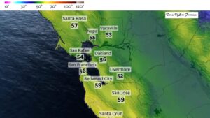
The storm is expected to track closely along the coast, increasing the risk of significant impacts across the Bay Area.
Flooding Threat: Roads Likely to Be Underwater
National Weather Service meteorologist Dylan Flynn warned that urban flooding is almost guaranteed during the storm.
Most Dangerous Time for Flooding
The heaviest rain is expected Tuesday night, when visibility will be poor and flooded roads will be difficult to see.
“If you’re traveling at night, especially around Christmas, you need to be extremely careful,” Flynn said. “It can be very hard to tell the difference between a flooded road and normal pavement in low visibility.”
Low-lying streets, underpasses, and poorly drained areas are at the highest risk.
Damaging Winds Expected Across the Region
Whether or not the storm officially becomes a bomb cyclone, it is expected to strengthen as it nears the Bay Area — a setup that often leads to powerful winds.
How Strong Will the Winds Be?
- Coastal wind gusts could exceed 55 mph
- Inland areas may see gusts over 45 mph
- Some coastal and mountain locations could experience gusts up to 65 mph
Strong winds are forecast from Tuesday through Thursday, with the highest risk beginning Tuesday afternoon and continuing into Wednesday morning. Another round of strong winds is possible on Christmas Day.
Why Tree Damage and Power Outages Are a Concern
The strongest winds are expected to blow from the south-southeast, which is unusual for the Bay Area. Most trees in the region are more accustomed to westerly winds and may be more vulnerable to falling.
In addition, several inches of rain before the storm will loosen soil, making it easier for trees to topple. Widespread power outages and downed trees are possible from the Bay Area north to the Oregon border.
Storm Track Raises Concern for Widespread Impact
The National Weather Service noted that the storm is expected to move nearly parallel to the Bay Area coastline. Combined with already wet conditions, this increases the risk of this being one of the most impactful storms of the season.
Similar bomb cyclones in recent years have caused severe wind damage, flash flooding in San Francisco, and river flooding across Northern California.
Conclusion
The Bay Area is facing a potentially dangerous storm next week that could rapidly intensify into a bomb cyclone. With heavy rain, nighttime flooding, powerful winds, and the risk of fallen trees and power outages, residents should prepare early and stay alert to weather updates.
Travelers, especially those heading out at night around the holidays, are urged to use extreme caution as conditions could change quickly.