The Pacific Ocean is still in a La Niña phase, but experts say the pattern is weakening fast. On Thursday, the Climate Prediction Center confirmed that cooler sea surface temperatures continue across the equatorial Pacific — but not for long. Scientists expect La Niña to fade completely by February.
La Niña Is Nearing Its End
According to Nat Johnson, a meteorologist at NOAA’s Geophysical Fluid Dynamics Laboratory, the current La Niña is already at its peak. He explained that ocean temperatures in the eastern Pacific should rise soon, pushing the region back to an ENSO-neutral phase within the next couple of months.

Right now, NOAA’s key measurement — the Niño-3.4 index — sits at -0.5°C, the exact threshold used to classify La Niña. That means the system is hanging on by a thread.
Could El Niño Return Quickly?
Once La Niña fades, forecasters expect a neutral phase for a short time. But growing evidence suggests that the Pacific could swing quickly into an El Niño pattern as early as summer 2026.
During La Niña, strong easterly winds push warm water toward the western Pacific, causing it to build up like water in a tilted tub. That is exactly what has been happening for months.
Warm Water Pool in the West Pacific
Recent ocean readings show historically warm temperatures across the entire western Pacific basin — some of the warmest ever recorded since 1950. This large pool of warm water is the “fuel” scientists say could trigger a fast shift toward El Niño.
Short bursts of strong winds, called westerly wind bursts, could push that warm water back toward the eastern Pacific. If that happens, temperatures across the basin could rise quickly, causing a sudden El Niño transition.
But It’s Not Guaranteed
Despite the warm water build-up, Johnson warns that having the fuel does not guarantee an El Niño. He compared the situation to 2014, when early signs suggested a major El Niño was on the way — but the winds never fully reversed. That delayed the event by a full year.
Models Suggest a Possible El Niño in 2026
Current long-range models show La Niña continuing through winter, shifting to neutral in spring, and raising the chances of El Niño during summer 2026. But a repeat of 2014 is still possible if the easterly winds don’t weaken.
What to Watch Over the Next Few Months
The Pacific Ocean is loaded with heat energy, and the next few months will determine whether that energy spreads across the basin. If the trade winds reverse and strong westerly wind bursts appear, the shift to El Niño could happen quickly.
A rapid return to El Niño by summer 2026 could mean a hotter-than-normal second half of the year globally. But if the winds remain steady, the Pacific may stay neutral longer, reducing the risk of extreme weather events.
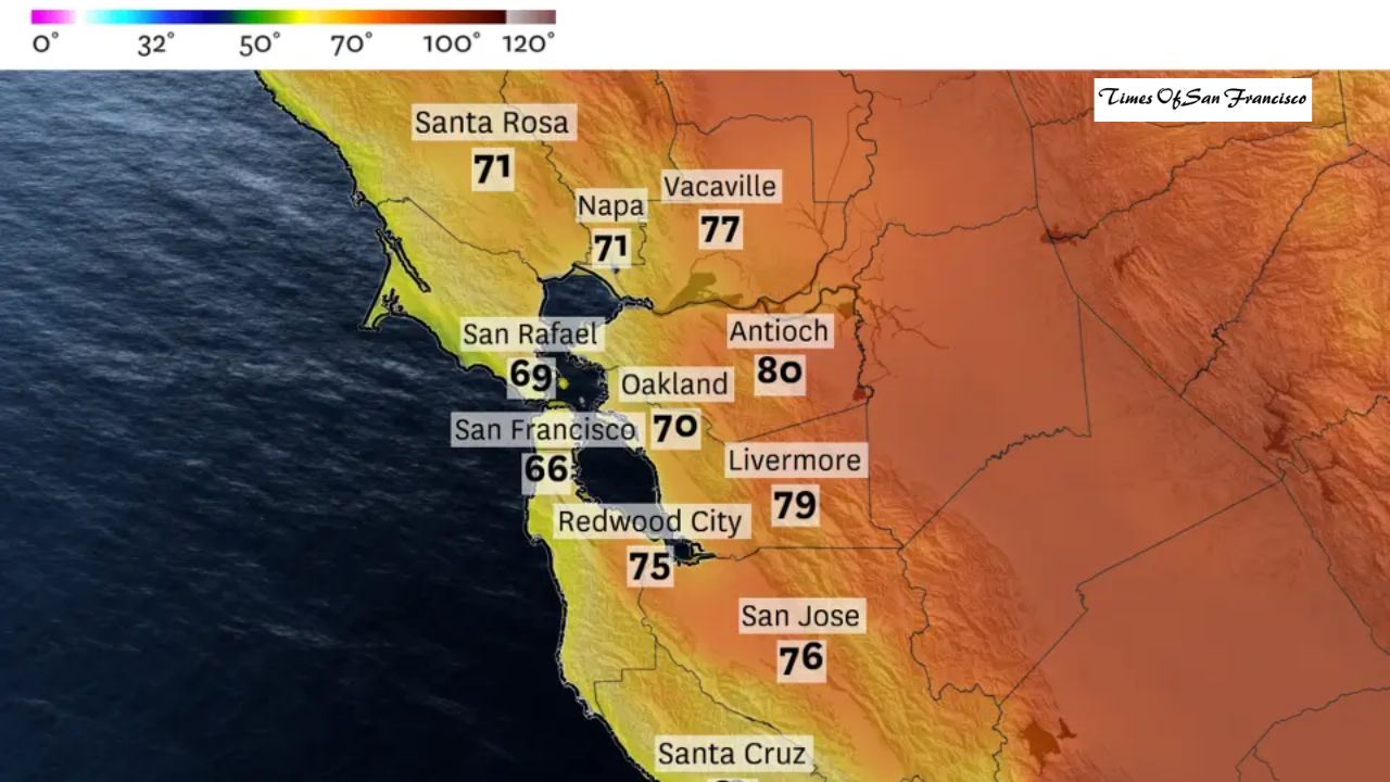
Impact on California
El Niño typically brings wetter weather to California, but recent years have shown that these impacts are not always predictable. Each El Niño behaves differently, so forecasts for 2026 remain uncertain.
Johnson says the key indicator to monitor is the tropical Pacific wind pattern. If strong westerly winds appear, that will be the clearest sign that the atmosphere is responding to the warming ocean.
Conclusion
The Pacific Ocean is preparing for a major shift. La Niña is fading, warm water is building in the west, and scientists say an El Niño could return as early as summer 2026. However, the transition depends heavily on wind patterns in the coming months. If the winds reverse, the world could see hotter weather and stronger climate impacts next year. If not, the Pacific may remain neutral for longer. For now, all eyes are on the tropical Pacific as the atmosphere decides what comes next.